

Where the Amazon river meets the Orinoco river:
Archaeology of the Guianas
Where the Amazon
river meets the Orinoco river:
Archaeology of the Guianas
S T É P H E N R O S T A I N
Centre National de la Recherche Scientifique (CNRS), France
Institut Français d’Études Andines (IFEA), Équateur
Rostain, S.
WHERE THE AMAZON RIVER MEETS THE ORINOCO RIVER. ARCHAEOLOGY OF THE GUIANAS
Abstract
Archaeological and interdisciplinary investigations conducted in the Guianas during these last 35 years offer a new picture of the pre-Columbian Guianas. Although archaeology still is relatively incipient in the Guianas, it is possible to draw up a panorama of the prehistory of this huge region. During the last millennium before the European Conquest, Guianas coast was divided into two main territories dominated by two different cultural entities. Cayenne Island in French Guiana was the key-area marking the boundary between two cultural traditions. Western coast up to the Guyana was dominated by cultures linked to the Arauquinoid Tradition originated in the Middle Orinoco. Eastern coast was occupied by cultures belonging to the Polychrome Tradition of the Lower Amazon. These two cultural entities grew up from ca. AD 600 up to their destruction by the European Conquest.
Keywords: Archaeology, Guianas, arauquinoid tradition, polychrome tradition
LÀ OÙ L’AMAZONE RENCONTRE L’ORÉNOQUE. ARCHÉOLOGIE DES GUYANES
Résumé
Les recherches archéologiques et interdisciplinaires menées dans les Guyanes durant ces 35 dernières années fournissent une nouvelle image des Guyanes précolombiennes. Bien que l’archéologie soit relativement jeune dans les Guyanes, il est possible de dresser un panorama de la préhistoire de cette immense région. Durant le dernier millénaire avant la Conquête européenne, le littoral des Guyanes était divisé en deux territoires principaux dominés par deux différents ensembles culturels. L’Île de Cayenne en Guyane française était une zone charnière marquant la frontière entre deux traditions culturelles. La côte occidentale était dominée par des cultures liées à la Tradition Arauquinoïde issue du Moyen Orénoque. Le littoral oriental était occupé par des cultures appartenant à la Tradition Polychrome du Bas Amazone. Ces deux entités culturelles se développèrent de 600 apr. J.-C. environ jusqu’à leur destruction par la Conquête européenne.
Mots clés: Archélogie, Guyanes, tradition arauquinoïde, tradition polychrome.
DONDE EL AMAZONAS ENCUENTRA EL ORINOCO. ARQUEOLOGÍA DE LAS GUYANAS
Resumen
Las investigaciones arqueológicas e interdisciplinarias llevadas a cabo en las Guyanas durante estos 35 últimos años muestran una nueva imagen de las Guyanas precolombinas. Si bien la arqueología es relativamente joven en las Guyanas, es posible presentar un panorama de la prehistoria de esta inmensa región. En el último milenio antes de la Conquista europea, el litoral de las Guyanas estaba dividido en dos territorios principales dominados por dos diferentes conjuntos culturales. La Isla de Cayena en Guyana francesa era una zona clave que marcaba la frontera entre dos tradiciones culturales : la costa occidental dominada por culturas ligadas a la Tradición Arauquinoide originaria del Medio Orinoco y el litoral oriental ocupado por culturas pertenecientes a la Tradición Policroma del Bajo Amazonas. Estas dos entidades culturales se desarrollaron cerca de 600 DC hasta su destrucción por la Conquista europea.
Palabras-clave: Arqueología, Guyanas, tradición arauquinoide, tradición policroma
INTRODUCTION
Up to recently, pre-Columbian developments of the Guianas were not well-known. During a long time this enormous piece of land located between the Orinoco and Amazon Rivers has been more productive for myths than for scientific studies. The myth of El Dorado, the Indian King covered of gold power before to plunge in a lake originated in Columbia. However, this tale was transposed in the earliest times of the conquest from Columbia to the Guianas to be located in the large savannas of the center of the country. Manoa, the city of Eldorado, has been located by Europeans in these central savannas, on the bank of the mythic Parimé Lake. Christopher Columbus was convinced to find the Eden when he visited the mouth of the Orinoco. After him, the quest of the Eldorado, but also of only gold, has been a leitmotiv among the people going to the Guianas. Guianas are also a land of nightmares where cannibals still threaten people. The anthropologist Neil Whitehead (2002) shown that in the central savannas of the Guianas, dark shamans continue today to kill and to make black magic on inhabitants. These anthropophagic rituals make by modern Kanaimas or dark shamans are a clear reminiscence of those described in the archives for the Tupi groups of coastal Brazil. We obviously also have the Amazon women, stars of tales of the pristine forest, who were supposed to live in the Guianas, just north of the Amazon River. What is interesting about the Amazons is the heresy that such women living without men represented in the 16th century world. These myths contributed to the conception of the existence of Evil in the Guianas.
Investigations conducted during 35 years, but especially in the last five years offer a very different picture of the Guianas, boring myths and legends of our minds. Although archaeology is still relatively incipient in the Guianas, we already can draw up a panorama of the pre-Columbian occupation of this huge region (Rostain 2008). During the last millennium before the European Conquest, Guianas coast was divided into two main territories dominated by two different cultural entities (Figure 1) and Cayenne Island was the key-area marking the boundary between two cultural traditions (Rostain 1994). This paper will show the differences between these two main pre-Columbian entities and will present some innovative interpretations from a recent scientific program conducted in French Guiana.
A SPECIFIC AMAZONIAN LAND
Guianas have a geographical and cultural uniformity, distinct from the Greater Amazonia. They cover some 1.8 million square kilometers and are divided into five countries: Venezuela (states East of the Orinoco River), Guyana, Suriname, French Guiana and Amapá (a state situated north of the Amazon River in Brazil). The Guianas are delimited by the Orinoco at north, by the Atlantic at east, by the Amazon river at south, by the rio Negro and the Cassiquiare canal at west. The Casiquiare is a geographical anomaly because this river connects two different river basins: the upper Negro and the upper Orinoco. Guianas are bordered on their periphery by water from rivers or ocean, so they form a vast continental island in Amazonia.
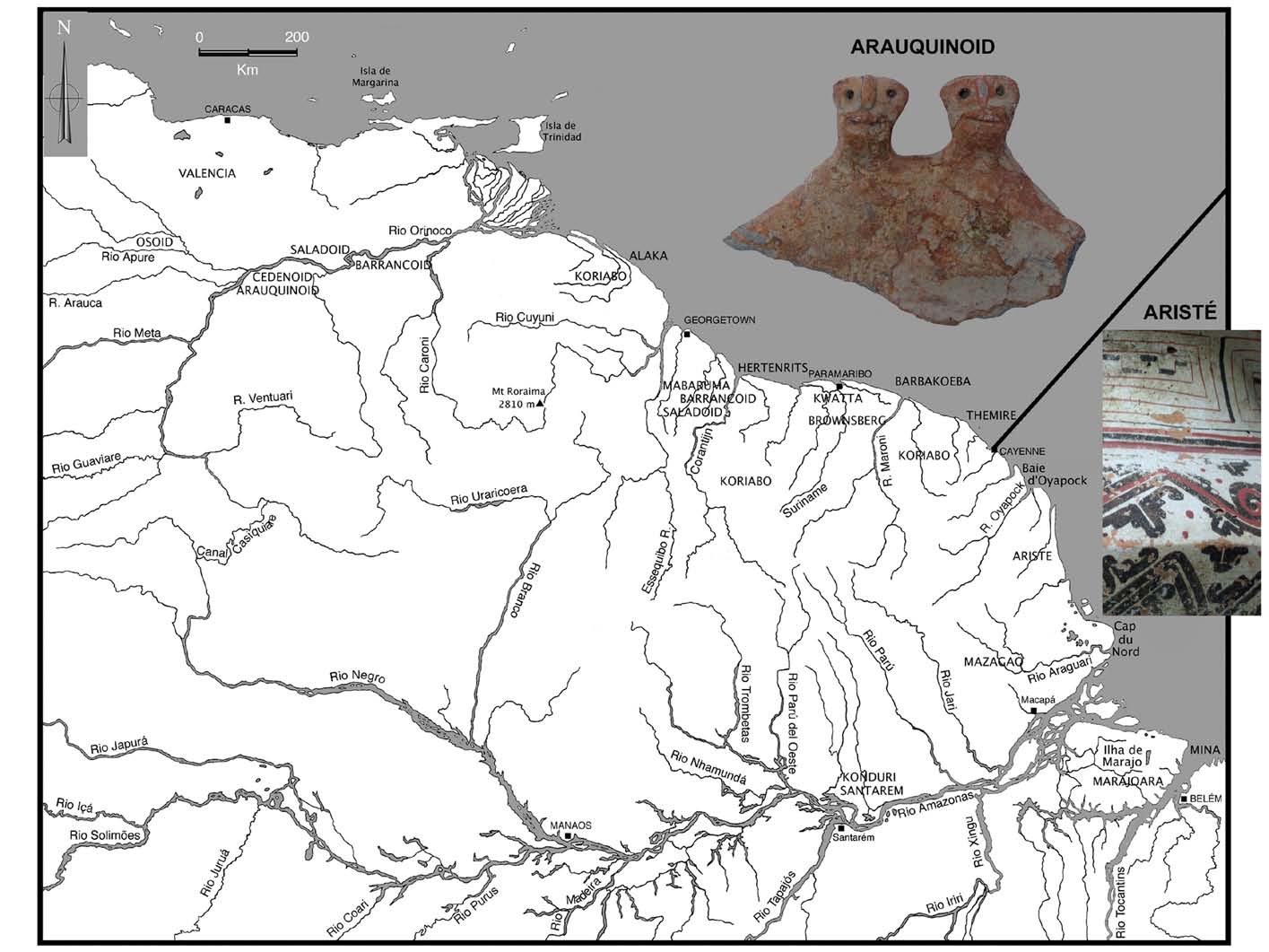
Figure 1 – Map of the Guianas showing the two main pre-Columbian territories and different archaeological cultures (drawing S. Rostain)
The periphery can be considered as a coast because rivers are so wide that they constitute sorts of seas.
The oceanic coast is a narrow Quaternary sedimentary plain stretching some 1.600 km between the mouth of the Amazon and the Orinoco Delta. The young coastal plain is differentiated from old the coastal plain. The first one is a low swampy plain bordered by mangroves on the mud flats along the seashore. On the old coastal plain, marshes are cut by narrow and elongated sandy ridges parallel to the seashore that are ancient beaches (Figure 2). The Amazon River measures almost 100 km wide at Santarém, so it was not easy to cross during pre-Columbian times. Inhabitants of the left side did not have regular contacts with those of the right side. Floodplains located along the rivers and the seashore are particularly fertile. Very efficient agricultural techniques, using terra preta or várzea, have been used on this periphery. This “continental coast” is fertile and was inhabited by the most complex pre-Columbian societies. So it is possible to say that Guianas are surrounding by a rich water ring.
The hinterland borders the coastal plain at the south and the interior is covered by the rainforest surrounding central savannas in Guyana, Suriname and Venezuelan tepuyes. For instance, the rainforest covers 90% of French Guiana. Seen from the sky, it has a “broccoli” aspect. The forest is the most varied vegetation formation in the world with more than 5,200 known species. Extended savannas are located at the center of the Guianas. The first inhabitants, hunter-gatherers, crossed them more than 10,000 years ago. The western part of the center is dominated by more than 100 tepuyes. These plateaus with vertical walls emerge from the forest to reach in some cases almost 3,000 m.
This paper presents the most recent prehistoric developments in the coastal Guianas. They are located north of the Guianas watershed line where rivers do not go from north to south toward the Amazon river but flow to the north toward the Atlantic Ocean. This concerns three countries that are Guyana, Suriname, French Guiana and three states that are Delta Amacuro y Bolivar (partially) in Venezuela and Amapá in Brazil.
WEST
Groups linked to the Arauquinoid Tradition dominated the Guianas coast west of Cayenne Island during almost one millennium. Although often cited in the archaeological literature, the Arauquinoid Tradition is, in fact, summarily documented in Venezuela (Cruxent & Rouse 1958-59). On the evidence of the published decorated pottery (style, technique, shape), it is possible to distinguish two main cultural entities in the Venezuelan Arauquinoid pottery (Rostain & Versteeg 2003). A clear dichotomy exists between the Apure-middle Orinoco ceramic repertoire (Caño Caroni, Matraquero, Arauquin, Camoruco, and Corozal sites) and the lower Orinoco ceramic repertoire (Guarguapo and Apostadero sites).
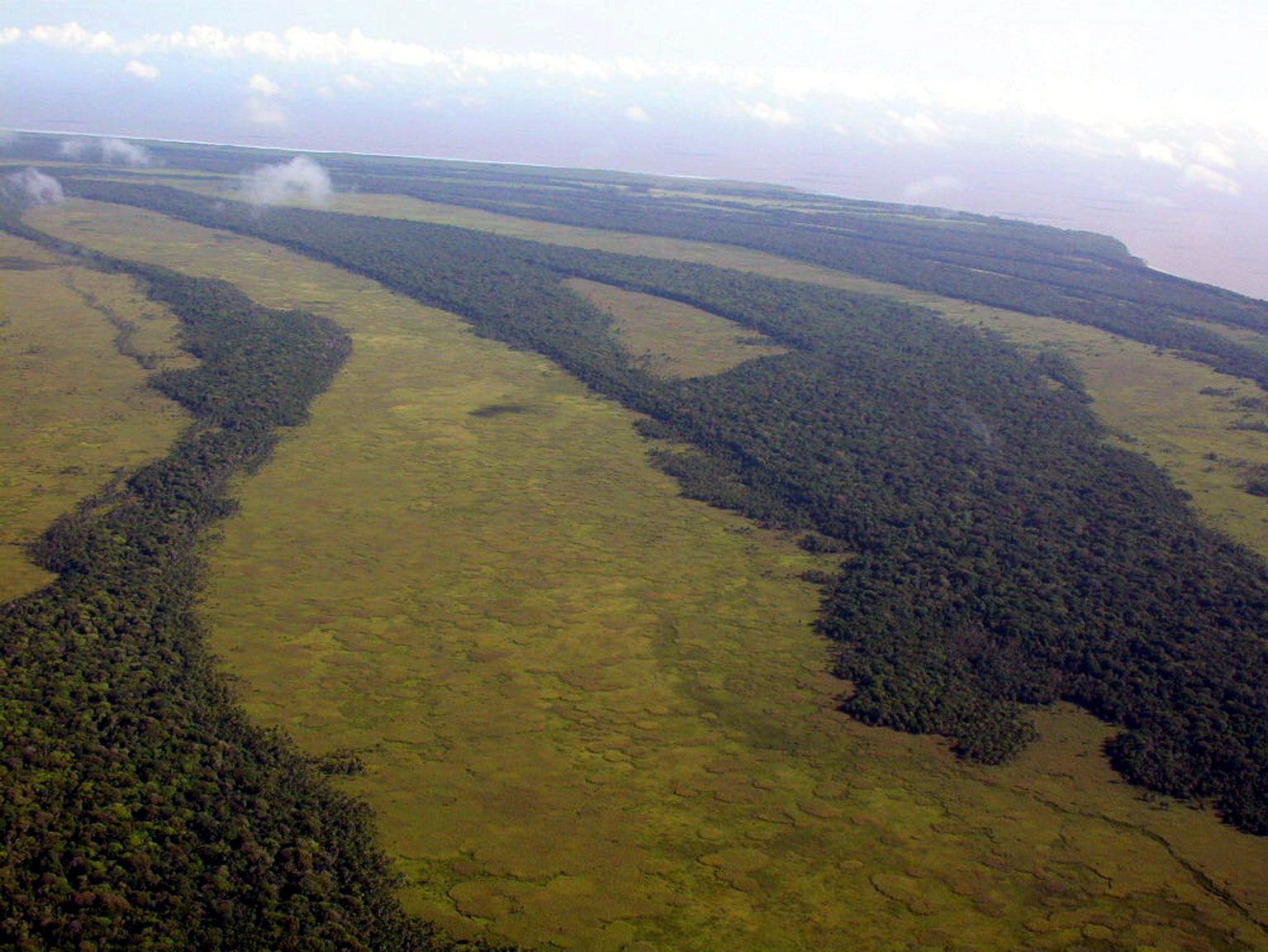
Figure 2 – Flooded coastal plain where elongated sandy ridges run parallel to the sea-shore, eastern Suriname (photo S. Rostain, 2005)
The chronological sequence in the Guianas shows a development that is more or less parallel to that in Venezuela. Like in the Orinoco Basin, the Saladoid Tradition is replaced by the Barrancoid Tradition that precedes the Arauquinoid Tradition. Diffusion of Arauquinoid aspects toward the east along the coast of the Guianas begins ca AD 650. The density of sites and probably of population in this area increases from this time on. The Arauquinoid influence came probably by inland routes because there is no evidence of Arauquinoid presence on the western coast of Guyana and information on trade routes from the Colonial period suggests that inland routes were preferably used to travel from the Orinoco to the Essequibo River (Arvelo-Jiménez & Biord 1994). The best interpretation is to consider these coastal cultures as a continuum, which successively spread over the coastal plain of the Guianas from the Orinoco area to the east (Rostain & Versteeg 2003). The earliest dating available for each culture also reveals a trend from west to east. In western Suriname, the early Mabaruma culture (Buckleburg – 1 and Buckleburg – 2 sites) begins in approximately AD 300. The Early Hertenrits style (Hertenrits and Wageningen – 1 sites) begins around AD 600. To the east, the Peruvia site (Hertenrits style with a number of important Kwatta aspects) is dated at approximately AD 700. In central Suriname, the Kwatta style begins in approximately AD 800. In east Suriname and west French Guiana, the Barbakoeba style would begin in circa AD 900, and the Thémire style in central French Guiana ca. AD 1300.
Along most of the Surinamese coast and the western half of the French Guiana coast settlements on the natural elevations in the landscape can be found on the sandy ridges (cheniers). These are the most likely natural settlement locations: slight elevations in the landscape with good drainage (Figure 3). Sandy ridges were ideal places to settle villages. So, pre-Columbian communities inhabited along these formations. They had an easy access to resources from the sea, the river, the forest and the savanna. Raised fields were built in swamps just south of the villages. Between the Berbice and the Coppename rivers in Guyana and Suriname, sandy ridges are absent, so the Hertenrits people had to build rounded clay mounds above the water level to erect their villages. Nine mounds were built in an ecosystem where fresh, brackish and salt waters met (seven are located in Suriname and two in Guyana). Hertenrits is the largest of the nine known mounds with a raised area of about 4 hectares (Boomert 1980). The total quantity of earthworks has been estimated on 14.000 truckloads. Archaeological excavations have shown that the Hertenrits mound was built by the piling up of rectangular blocks and a wooden shovel perfectly adapted to such work has been found in a close site (Versteeg 2003).
Each Arauquinoid group was specialized in specific activities like ceremonial rituals, trade, intensive agriculture, tools and artefacts’ manufacture. The Arauquinoid pottery is decorated with thin incision, punctuation or anthropomorphic figures and the characteristically twin items. Pregnant figurines are common (Figure 4). However, it was not a much elaborated industry. Their most famous product was the muiraquitã (Boomert 1987). These are green stone pendants representing mostly frogs. The archives also describe Indian myths about these objects: the muiraquitãs were made by the warrior women Amazons who molded clay from a lake in the shape of a frog; the clay became hard as a rock when it was taken out of the water. In reality, three centres for the manufacture of muiraquitãs, all connected with the Arauquinoid sphere, are known in Amazonia: the Santarém area in the Lower Amazon, the Valencia Lake in Venezuela, and the just south of Paramaribo in Suriname that is the centre of the Arauquinoid territory in the Guianas (Rostain 2006).
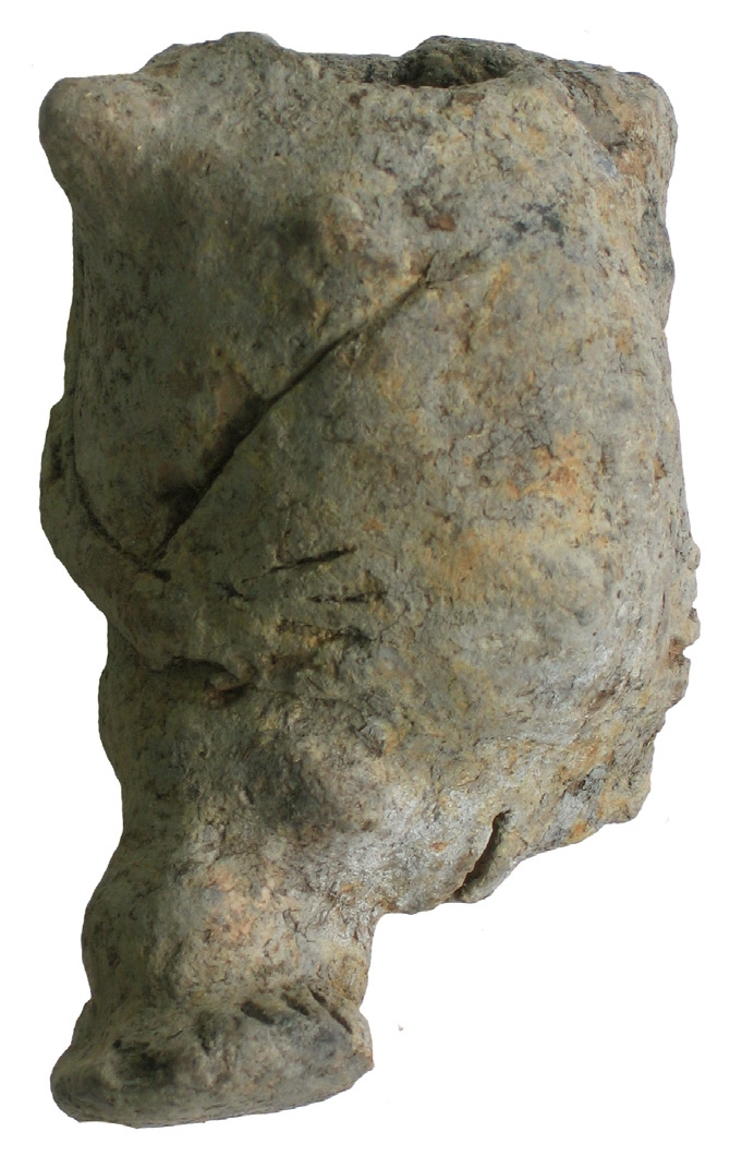
Figure 3 – Excavations at the Bois Diable site, on a sandy ridge west of Kourou, Arauquinoid Tradition (photo S. Rostain, 2008)
Arauquinoid peoples are mainly famous for another activity. They built thousands of raised fields that are an impressive and ingenious agricultural answer to the flooding coastal plain of the Guianas (Figure 5).
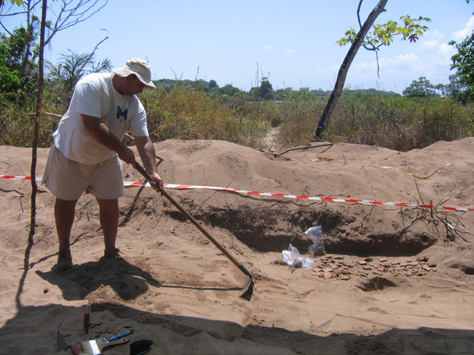
Figure 4 – Pregnant figurine from the Arauquinoid site of Prins Bernhard Polder, western coast of Suriname, collection of Stichting Surinaams Museum, Paramaribo (photo S. Rostain, 2009)
In the Guianas, Arauquinoid people occupied a territory of approximately 600 km long between Guyana and French Guiana, where the raised-field technique was intensively used for almost one millennium before the European Conquest. Arauquinoid communities had settled between the Berbice River in eastern Guyana and Cayenne Island in French Guiana. The highest density of raised fields is found in the east of the Arauquinoid territory, particularly between Iracoubo and Kourou in French Guiana, where the last Arauquinoid communities survived. In this area, it seems that almost every flood spot was used for agricultural purposes. Complexes of raised fields have a specific organization. The nature and distribution of agricultural mounds depend both on the topography and water levels, but variations of shape and organization can be seen inside one complex.
The distribution and the shape of raised fields are related to water level and altitude. For instance, in a complex located along the slope of a quaternary sand ridge, large rounded raised fields are built in the deepest part of the swamp, while elongated raised fields follow the direction of the slope to allow easy drainage at the foot of the quaternary sand ridge, and the ridged fields are laid perpendicular to the slope for optimal water retention on the upper part (Rostain 2010). This implies a large labor force and, probably, planning under the authority of a leader. Shape and layout of raised fields responded to specific constraints and reveal a subtle knowledge of various environmental factors.
The most advanced studies on raised fields in the Guianas have been made in French Guiana. The first program was conducted between 1989 and 1991 (Rostain 1991). The second one was carried out from 2007 to 2011 (McKey et al. 2010; Rostain 2010). If Arauquinoid pottery was quite well-known, dating was missing to define a precise chronological framework. For that reason, we performed 66 radiometric dates on samples collected in domestic sites and raised fields. It was the first time that raised fields were dated with precision in the Guianas. Dates from domestic sites confirmed the chronology previously defined (Rostain 2008); the raised fields were dated between AD 900 and 1300 in several complexes. The first Arauquinoid raised fields probably existed since AD 650 in western Suriname (Versteeg 2003) but they became common and spread almost everywhere along the coast from AD 900 and up to AD 1400 at least.
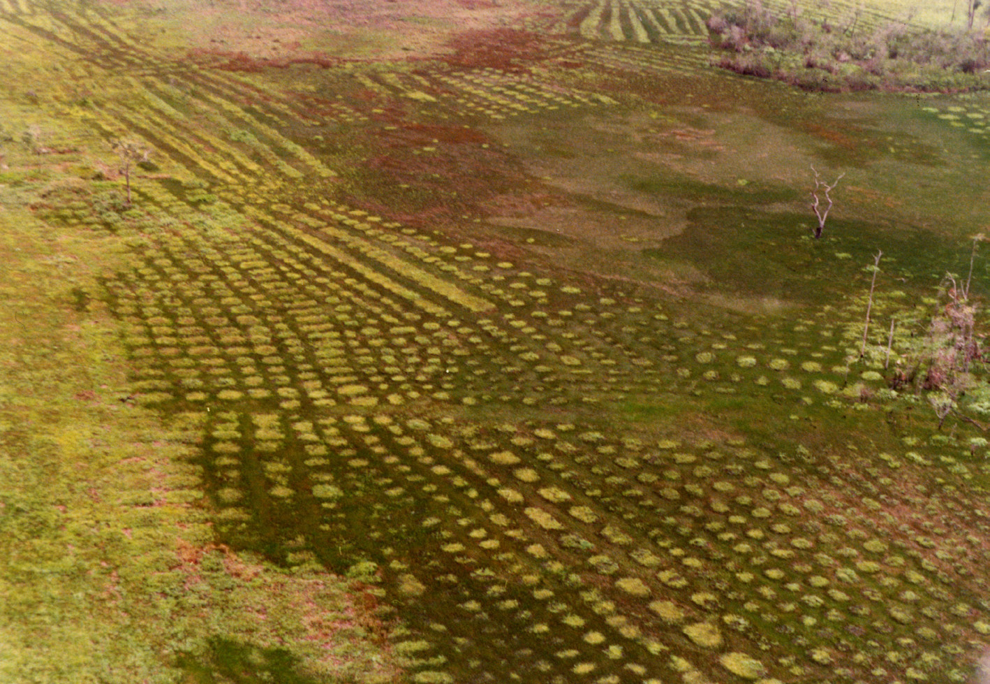
Figure 5 – Raised fields in the Karouabo area, central coast of French Guiana (photo S. Rostain, 1989)
One of the main questions posed by the raised field study is to know what plants were cultivated. Soil samples were collected from various raised fields complexes along the French Guiana coast. Archaeobotanists analyzed pollen and phytolith samples to find out what plant species were cultivated on these mounds. Maize was the main crop cultivated on raised fields. Looking at other archaeological data in Amazonia, it reasonable to conclude that these groups did not base their diet on manioc but were more maize oriented. During our recent “earthmovers” research (McKey et al. 2010), phytolith analysis from raised fields were combined with the analysis of starch grains from ceramic griddle sherds of the nearby domestic dwellings, to see correspondences between cultivated and consumed plants. Maize (Zea mays) and manioc (Manihot esculenta) were cooked on griddles (Iriarte et al. 2010 ; McKey et al. 2010). Moreover, cultivation of maize, squash (Cucurbita sp.), and perhaps sweet potatoes (Ipomoea) and arrow leaf (Xanthosoma) has been demonstrated on French Guiana raised fields.
If raised fields are the main earthworks made by the Indians, these landscape makers also built other structures. Artificial residential mounds are associated to raised-fields complexes in Suriname, Guyana and Venezuela. Canals are frequently associated to agricultural structures to improve drainage. But not all had an agricultural function. Small rivers have been diverted and canals have been dug to facilitate circulation. Similarly, pathways have been raised to cross the flooded areas.
Finally, raised field study conducted during the “earthmovers” project brought an interesting paradox looking at the tropical agriculture. The main plague for rainforest agriculture is the leaf-cutter ant, a fungus-growing ant that cut pieces of leaves to bring back to the nest. These insects are particularly voracious. For example, some Atta species are capable of defoliating an entire citrus tree in less than 24 hours. Leaf-cutter ants can be considered as quite a nuisance to humans because they defoliate crops and destroy plantations. However, the same ant also permits the preservation of raised fields. Ants act as “central place foragers” and as “mound builders” (McKey et al. 2010). They construct deep nests, bringing subsoil to raised field surfaces. Ants move materials to the raised fields where they set their nest. Acromyrmex workers carry large quantities of plants to the nest to feed their fungal symbiont. Moreover, transport of material to surfaces of abandoned raised fields thus at least partially compensates losses due to erosion and maintains the mound height. By reducing the erodibility of raised fields and by transporting materials to them, thereby compensating erosional losses, communities of ecosystem engineers on raised fields maintain the concentration of resources (and organisms) on raised fields and their depletion in the surrounding matrix. In conclusion, ecosystem engineers are responsible for the preservation of pre-Columbian raised fields up to nowadays. They are ants, earthworms, termites and even plants. Each of them played a function more or less important. It is curious to outline that after their abandonment by human social mammals, raised fields were managed and preserved by natural social insects.
EAST
The pre-Columbian situation was completely different in the East. Local populations had even few exchanges with the western ones. If most of the western coast of the Guianas was occupied by Arauquinoid cultures from AD 700 on, the eastern part of the Guianas was dominated by people originating from the middle and the lower Amazon. These groups were affiliated to the Polychrome Tradition: the territory of the Aristé culture extended along the coast from the Araguari river in Amapá to the Ouanary Hills in French Guiana, that is an area of circa 370 km long by 10 to 100 km wide; the Maracá culture extended along a river in southern Amapá; the Mazagão culture was located in southern Amapá; the Caviana culture occupied some islands of the mouth of the Amazon and the coast of the southern Amapá (Rostain 2011).
The Oyapock bay is a very special region, with remarkable coastal hills, being the first place to where European explorers generally arrived after crossing the ocean. So, it is a region frequently visited by Europeans just after the conquest. The main specificity of the Oyapock bay is the presence of coastal hills, which are rare on the coast of the Guianas. They are low, less than 200 m altitude, but they are especially visible from the sea (Figure 6). These coastal hills obviously were attractive for the Indians. The villages, smaller than the Arauquinoid ones, were settled on the small hills emerging from the swamps. The large size of the habitation sites, the high density of cemeteries and rock-shelters, and the diversity of ceramic innovations suggest that the lower Oyapock River hosted an important Aristé development centre. During historic times, confederate leaders of Amapá tribes lived in this area, which suggests its function as an important political centre during that period.
The specific distribution of the Ouanary Hill’s sites suggests that villages were surrounded by various ceremonial sites. The settlements were located in the middle of the southern slope, in a central position, on the opposite side of the seashore. The rock shelters, slightly above the villages, probably provided covered areas for temporary periods of isolation. Disposal of the dead occurred in caves at the top of the hills facing north. Excavations in the Ouanary Hills shown that the Aristé culture is characterized by two types of habitation sites: villages and rock shelters. The first ones are located on hills or river banks. Small settlements where a few families could live together are distinguished from larger villages where more extensive communities lived together. Small rock shelters, with the average size of 28 m2, were temporarily inhabited at different times by different people, while the main living units were found in the villages. The finds in the Ouanary Hill's rock shelters suggest a ceremonial function for these specific sites that may have been used as retreat locations (Figure 7). The archaeological record of the Aristé sites notes a considerable number of ceremonial sites. In fact, the majority of the sites have a ce-remonial, and not a habitation background. The division might reflect the importance of ceremonial/ritual components in Aristé culture.
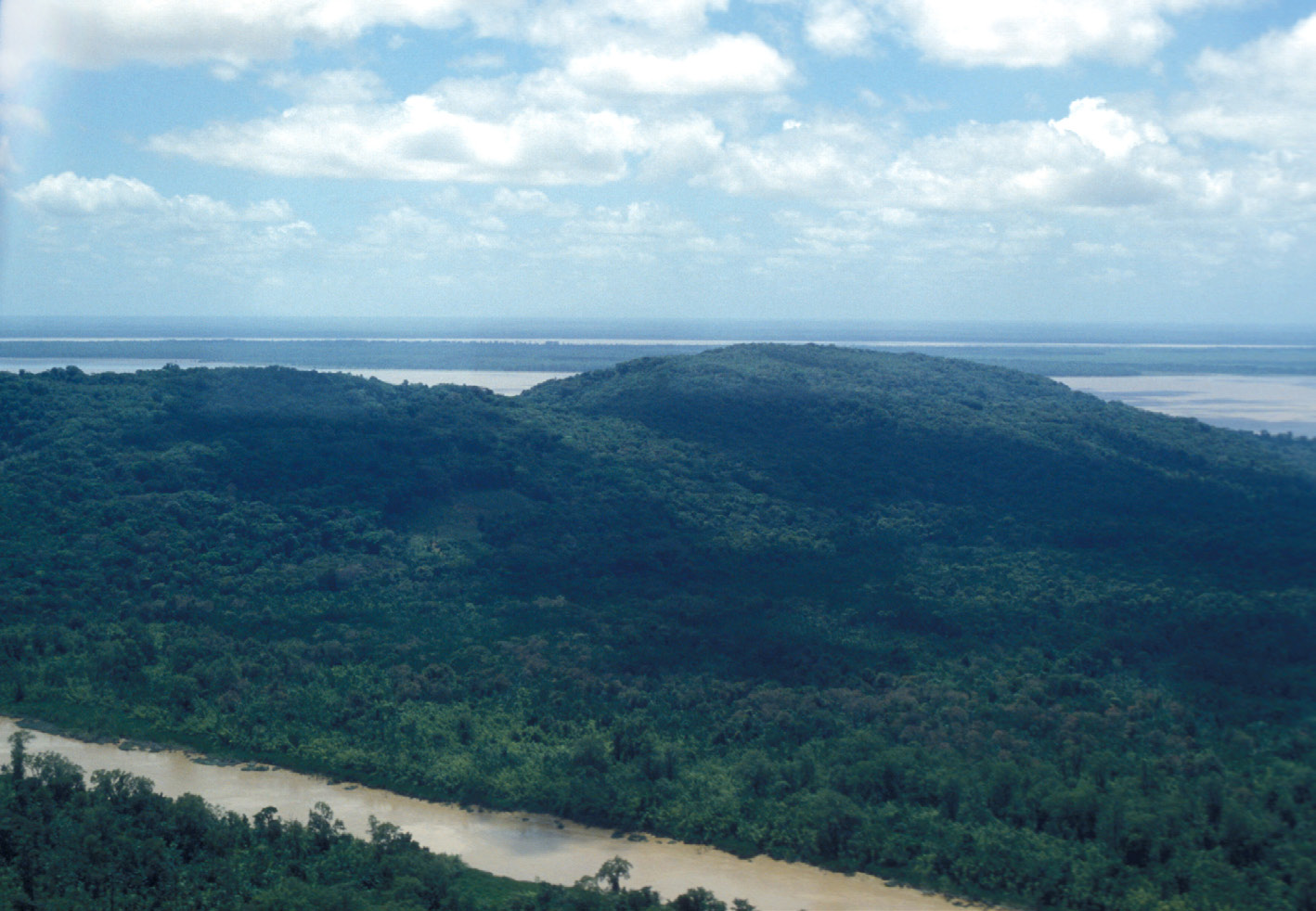
Figure 6 – Bruyère Hill was the center of Aristé confederation. Ouanary River is in the foreground, Oyapock River behind and Uaça River background (photo S. Rostain, 1989)
Megalithic sites are found on the central coast of Amapá, generally on hills, which are characterized by large panoramas. They consist of vertical granite slabs that are arranged in lines, circles or triangles. Such sites remind fertility and marriage rituals practiced with wooden and stone idols by Arauakí, Tapajós, and Trombetas of the middle Amazon during the 17th century. Recent excavations made by Mariana Petry Cabral and João Darcy de Moura Saldanha (Cabral & Saldanha 2009) in the megalithic site of Rego Grande demonstrated a funerary used but also an astronomic function.
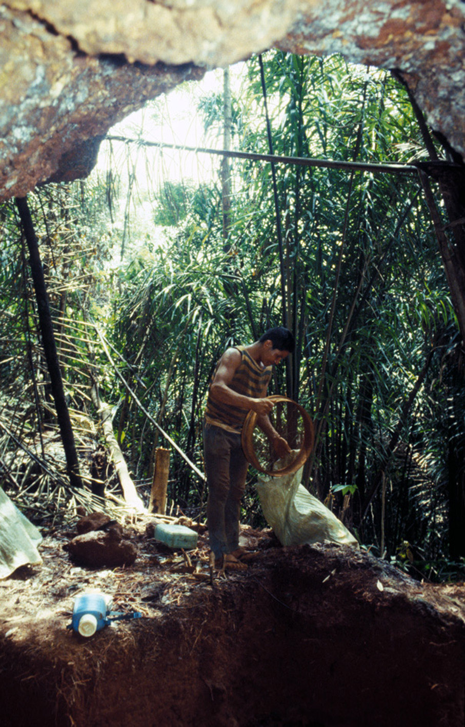
Figure 7 – Excavation in the Abri Marcel rock-shelter in the Bruyère Hill (photo S. Rostain, 1989)
Secondary burial in urns was practiced, and different Aristé cemeteries are recognized. In the lower Oyapock River, funerary caves are the most common. Urns were generally put against the wall of the cave. In other cemeteries, urns are arranged in a row on the ground or buried. They also can be put in shaft tombs dug where caves are absent. The Early Aristé culture is characterized by secondary urn burial containing bone remains after decomposition of the dead body. Late Aristé culture, however, presents another type of urn burial: the dead body was cremated before the remains were deposited in an urn (Meggers & Evans 1957). The latter type is predominant in Late Aristé culture, but the former and older type still occurs. Anyway, it seems that each cemetery was used for a long time by different clans, explaining the diversity of decorated urns in the same place. Gathered in an open cemetery, a cave or a pit, urns constituted an assembly of transformed beings, which recreates the meetings of livings in a closed microcosm. Everything indicates that, in spite of a change of state, the community life and the cultural identity are re-formed for dead, as a wish to perpetuate forever a mirror image of the society. Even after death, existence is essentially social, based on the recognition of the other and not on the individual dynamic.
Shape and decoration of the funerary Aristé ceramics are very diverse and reveal a high level of creativity. But the most characteristic in this ceramic is the anthropomorphic features associated to the urns: face, arms, legs, nipple and navel. Like in other Polychrome cultures of the lower Amazon, body paintings were drawn on anthropomorphic urns to claim their cultural affiliation (Figure 8). The Aristé confederation is expressed by the uniformity of this culture and the “personification”of the urns, by the precise geographical borders and the extreme scarcity of non-Aristé trade artefacts. Several villages obviously shared a common material culture and participated in a local trade system. The limited number of urns in each Aristé cemetery may indicate that these burials were reserved to persons of high status such as clan or tribal chiefs. Moreover, the large number of cemeteries, each containing few dead and/or urns, and the variety of the urn decorations, may indicate clan divisions. These peculiarities are the manifestation of the different units within the homogeneous Aristé cultural community. Aristé pottery has three different styles, which represent successive phases in the long-standing chronology of Aristé culture (Rostain 2011): Ancient Aristé (AD 700-1100), Late Aristé (AD 1100-1600), and Final Aristé (AD 1600-1750).
Aristé people lived in an area frequently visited by Europeans from the beginning of their colonization. Aristé cemeteries were still used during colonial times. It is very common to find European artifacts among Indian offerings in Aristé cemeteries. These are glass beads, earthenware from Holland, iron tools, etc. In the cemeteries with European trade items (glass sherds, nails, knives, rings, chinaware, small bells, and medals), the presence of glass beads, melted and sometimes mixed with burnt human bones, suggests that the dead were burnt with prestigious artefacts. The presence of chinaware made in the Netherlands between 1670 and 1750 in funerary caves suggests that they were still used in the 18th century. In fact, these historical period cemeteries seem to represent the latest Aristé culture manifestations, while also showing the absorption of new culture elements. The Aristé culture lasted up to ca AD 1750 and it is the only homogeneous and well-represented archaeological culture of north Amapá and the Ouanary Hills.
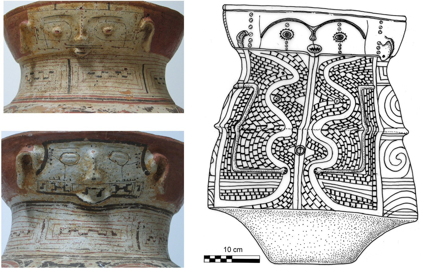
Figure 8 – Left: human faces made in relief of the neck of two Aristé painted urns from the Trou Biche cave, in the Bruyère Hill in the mouth of Oyapock, collection of Museum of Guyanese Culture, Cayenne (photo S. Rostain, 2004). Right: funerary anthropomorphic and polychromic urn of the Cunaní pit in Amapá (drawing S. Rostain)
Historical records from the end of the 16th century, and of the same area, shows that several Indian groups, notably the modern Palikur (Aruak linguistic family), were predominant there after the conquest (Nimuendajú 2008 [1926]; Grenand & Grenand 1987). This brings into view one question: Are Aristé people “ancestors” of modern Palikur? Few similarities exist between Aristé and Palikur ceramic styles (Rostain 2011). While the Palikur potters do not use curved and elaborate lines in designs of the Late Aristé style, they would recognize the linear, triangular and castellated designs of both the Incised-and-Punctate and Arauquinoid Traditions. The modern Palikur style originates from a mixture of Aristé, Mazagão, and some Arauquinoid styles resulting in an evolution of a new pottery style. To find the real Aristé heirs, we have to move to the west along the Guianas coast. The landing of the European in 1499 dealt a serious blow to the Indian world as it was prior to the Conquest. A complete destabilization occurred, provoked by that arrival. Hybrid communities arose, due to the interaction of several local populaces. Kali’na culture (Karib linguistic family) issued from eastern Polychrome Tradition settled between Cayenne Island and Orinoco Delta.
CONCLUSION
Archaeological excavations and analysis made during the 20th century and at the beginning of this century authorize us to draw a panorama of the pre-Columbian occupation of the coastal Guianas. Thanks to important progresses, especially in microanalysis, made in archaeology and the multiplication of researchers working in this area in the last years, this framework will obviously be soon completed, detailed, and modified. However, it furnishes a basis to understand the prehistory of the area and to orient interpretations. Up to now, the recent studies made in the five Guianas confirm this pre-Columbian dichotomy between two main cultural territories along the coast separated by Cayenne Island. No other convincing framework to explain pre-Columbian world has been proposed.
However, recent scientific programs reveal new fundamental data in the Guianas on the antiquity of the pottery, the agriculture and the nature of cultivated plants, the function of sites, and the landscape modifications. These promising investigations are the University of Guyana project conducted by Michael Heckenberger in eastern Guyana, the INRAP preventive excavations in French Guiana (Van den Bel 2009, 2010), the IEPA researches in Amapá (Saldanha & Cabral 2010; Cabral 2011) and the CNRS interdisciplinary project in the coastal flooding savannas in French Guiana (Iriarte et al. 2010; McKey et al. 2010; Rostain 2010). During these last five years, important sites have been discovered and studied, such as raised fields and domestic artificial mound in Guyana, enormous raised-field complexes and associated sites west of Kourou in French Guiana, pre-ceramic and formative sites in western coastal French Guiana, ditched hills or elevations near rivers in French Guiana, cemeteries, funerary pits, and stone alignments in central Amapá and the Lower Oyapock River. These are not anymore excavated by restricted test-pits dug by one or two amateurs but by large teams of professionals. Large-scale excavations become more common among archaeologists. Multidisciplinary or even interdisciplinary researches are frequently conducted and almost all archaeological works are now associated with other disciplines like pedology, botany, geomorphology, ecology, ethnology, etc.
The future is also optimistic given the clear increase of academic studies in the Guianas. Up to the beginning of the 21th century, only three PhDs were obtained in Amapá (Meggers & Evans 1957), Suriname (Versteeg 1985), and French Guiana (Rostain 1994). A new generation of archaeologists came to work in these countries and several PhDs are in process in Amapá (Federal University of Pará in Brasil), French Guiana (University of Pantheon-Sorbonne in France) and Suriname (University of Leiden in Holland). More books and scientific papers are also published and it is noteworthy the quantity of chapters concerning Amazonian lowlands, and especially the Guianas, in the recent “Handbook of South American Archaeology” (Silverman & Isbell 2008).
Up to recently, pre-Columbian Guianas were almost always forgotten in any study on the prehistory of Amazonia. One good example is the excellent book “Unknown Amazon” (McEwan, Barreto & Neves 2001) where, however, all the lands north of the Guianas watershed were completely ignored. The remarkable progress and discoveries made in these last years in the Guianas has changed the vision on the cultural developments and the role of this territory during the pre-Columbian times. Archaeologists are now aware of the importance of the northern part of the lower Amazon, especially the Amapá State, as a crucial cultural cradle (Neves 2006; Schaan 2012), but also of the extraordinary pre-Columbian human developments in the Guianas and particularly along the coast.
The prehistory of the Guianas has been at last waked up from its isolation.
REFERENCES
Arvelo Jiménez, N. & H. Biord. 1994. The impact of Conquest on contemporary indigenous peoples of the Guiana Shield: the system of Orinoco regional interdependence, in Amazonian Indians from Prehistory to the Present: Anthropological Perspectives. Edited by A.C. Roosevelt, pp. 55-78. Tucson: University of Arizona Press.
Boomert, A. 1980. Hertenrits: an Arauquinoid complex in northwest Suriname. Journal of the Walter Roth Museum of Archaeology and Anthropology 3(2): 68-104.
_____. 1987. Gifts of the Amazons: “Green Stone” pendants and beads as items of ceremonial exchange in Amazonia and the Caribbean. Antropológica 67: 33-54.
Cabral, M. P. 2011. Juntando cacos: uma reflexão sobre a classificação da fase Koriabo no Amapá. Amazônica. Revista de Antropologia 3(1): 88-106.
Cabral, M. P. & J. D. M. Saldanha. 2009. Note sur des structures mégalithiques en Guyane brésilienne. Journal de la Société des Américanistes 95(1): 97-110.
Cruxent, J. M. & I. Rouse. 1958-59. An archaeological chronology of Venezuela. Social Science Monography 6. Washington: Pan American Union.
Grenand, P. & F. Grenand. 1987. La côte d’Amapá, de la bouche de l’Amazonie à la baie d’Oyapock, à travers la tradition orale Palikur. Boletim do Museu Paraense Emilio Goeldi .Antropologia 3(1):1-77.
Iriarte, J., B. Glaser, J. Watling, A. Wainwright, J. Birk, D. Renard, S. Rostain & D. McKey. 2010. Agricultural landscapes of coastal Amazonia: Phytolith and carbon isotope analysis of raised fields from French Guiana savannah. Journal of Archaeological Science 37(12): 2984-2994.
McEwan, C., C. Barreto & E. Neves (eds.). 2001. Unknown Amazon. Culture in Nature in Ancient Brazil. London:The British Museum Press.
McKey, D., S. Rostain, J. Iriarte, B. Glaser, J. Birk, I. Holst & D. Renard. 2010. Pre-Columbian agricultural landscapes, ecosystem engineers and self-organized patchiness in Amazonia. PNAS 107(17): 7823-7828.
Meggers, B. J. & C. Evans. 1957. Archaeological investigations at the mouth of the Amazon. Bureau of American Ethnology, bulletin 177. Washington DC: Smithsonian Institution.
Neves, E. G. 2006. Arqueologia da Amazônia. Rio de Janeiro: Zahar.
Nimuendajú, C. 2008 [1926]. Les Indiens Palikur et leurs voisins. Encyclopédie Palikur 1, CTHS, Orléans.
Rostain, S. 1991. Les champs surélevés amérindiens de la Guyane, Coll° La Nature et l’Homme, ORSTOM, Cayenne.
____. 1994. L’occupation amérindienne ancienne du littoral de Guyane, TDM 129. Paris: ORSTOM éditions.
____. 2006. Spécialisation et commerce dans les Guyanes amérindiennes. Techniques et cultures 46-47: 139-174.
____. 2008. The archaeology of the Guianas: an overview, in Handbook of South American Archaeology, pp. 279-302. Edited by H. Silverman & W. Isbell. New York: Springer/Kluwer/Plenum.
____. 2010. Pre-Columbian earthworks in coastal Amazonia. Diversity 2(3):353-369.
____. 2011. Que hay de nuevo al Norte: apuntes sobre el Aristé. Revista de Arqueologia 24(1): 10-31.
Rostain, S. & A. H. Versteeg. 2003. The Arauquinoid Tradition in the Guianas, in Late Ceramic Societies in the Eastern Caribbean, pp. 233-250. Edited by A. Delpuech & C. Hofman. BAR 1273, Monographs in American Archaeology 14. Paris.
Saldanha, J. D. M. & M. P. Cabral. 2010. A Arqueologia do Amapá: reavaliação e novas perspectivas, in Arqueologia Amazônica, Vol. 1., pp. 95-112. Edited by E. S. Pereira & V. Gua¬pindaia. Belém: MPEG/IPHAN/SECULT.
Schaan, D. 2012. Sacred geographies of ancient Amazonia. Historical ecology of social complexity, Walnut Creek: Left Coast Press.
Silverman, H. & W. Isbell (eds.). 2008. Handbook of South American Archaeology. New York: Springer/Kluwer/Plenum.
Van den Bel, M. 2009. Les dépôts funéraires d’Iracoubo: les résultats d’une fouille préventive d’une nécropole précolombienne en Guyane française. Amazônica, Revista de Antropologia 1(1): 230-249.
____. 2010. A Koriabo site on the Lower Maroni River: results of the pre¬ventive archaeological excavation at Crique Sparouine, French Guiana, in Arqueologia Amazônica, Vol. 1, pp. 61-93. Edited by E. S. Pereira & V. Guapindaia. Belém: MPEG/ IPHAN/ SECULT.
Versteeg, A. H. 1985. The prehistory of the young coastal plain of west Suriname. Ber. Rijksdienst Oudheidkundig Bodemonderzoek 35:653-750.
____. 2003. Suriname voor Columbus/Suriname before Columbus. Libri Musei Surinamensis 1. Paramaribo: Stichting Surinaams Museum.
Whitehead, N. 2002. Dark shamans. Kanaimà and the poetics of violent death. Durham/London: Duke University Press.
Recebido em 15/02/2012.
Aprovado em 08/03/2012.
Amazônica 4 (1): 10-28, 201
© As/os autoras/es que publicam na Amazônica Revista de Antropologia (ARA) retêm os direitos autorais e morais de seu trabalho, licenciando-o sob a Licença Creative Commons Atribuição-SemDerivação Works 3.0 Brasil que permite que os artigos sejam reutilizados e redistribuídos sem restrições, desde que o trabalho original seja citado corretamente.
|
This is an open-access website under the terms of the Creative Commons Attribution-NoDerivatives License. |
